


Plan du Tour en raquettes

Chabard
User
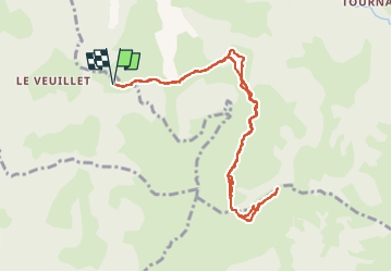

Length
9.9 km

Max alt
1711 m

Uphill gradient
546 m
Km-Effort
17.2 km

Min alt
1231 m

Downhill gradient
545 m
Boucle
Yes
Creation date :
2023-02-27 07:37:54.0
Updated on :
2023-02-27 16:27:57.835
3h06
Difficulty : Medium

FREE GPS app for hiking
 SityTrail
IGN / Geographical institutes
SityTrail Plus
The world is yours!
About
Trail Snowshoes of 9.9 km to be discovered at Auvergne-Rhône-Alpes, Upper Savoy, Les Clefs. This trail is proposed by Chabard.
Description
Plan du Tour en raquettes
Positioning
Country:
France
Region :
Auvergne-Rhône-Alpes
Department/Province :
Upper Savoy
Municipality :
Les Clefs
Location:
Unknown
Start:(Dec)
Start:(UTM)
294878 ; 5079682 (32T) N.
Comments